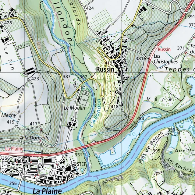
The village of Russin occupies a central position, situated on a slope above the Allondon river valley.
Read full description
The village of Russin occupies a central position, situated on a slope above the Allondon river valley. The settlement is clustered around a network of small roads and paths, with buildings concentrated primarily between the 419 and 418 elevation markers. To the south of the main village center lies the hamlet of Le Moulin, connected to Russin by a winding road that follows the contour of the hill.
The Allondon river flows from the northwest to the southeast, carving a valley through the landscape. Its course is flanked by green, wooded areas and slopes that rise toward the northwest. A blue line tracks the river's path, passing between Le Moulin and the main body of Russin. Further south, the Allondon joins a larger body of water, which flows eastward, bordering the area known as Prés de Bonne.
A primary road, marked with a red and yellow line, runs north-to-south along the eastern edge of the Russin settlement, curving southeastward to cross the river near the 384 elevation marker. This road connects the village to the region of Les Christophes to the northeast and leads toward La Plaine to the southwest.
In the southwestern corner, the settlement of La Plaine is situated on lower ground, characterized by a denser grid of buildings and roads. A wastewater treatment plant (STEP) is located on the edge of La Plaine, positioned between the residential area and the riverbank.
The terrain is marked by varying elevations, with the highest points appearing in the northwest near the 428 and 424 markers and the lowest points along the riverbeds. Contour lines indicate steep slopes descending from the plateau of Russin and the hills of La Fin toward the valley floor. To the east, the land levels out slightly toward Teppes, while the southeastern area features the undulating terrain of Les Roches.